


SERVICES

SLAM LiDAR SCAN
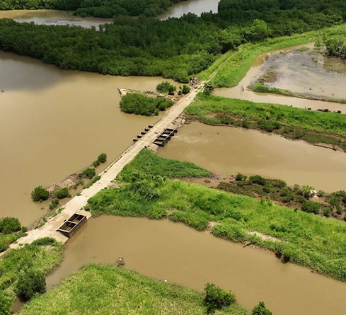
TOPOGRAPHIC SURVEYING
Are you looking for accurate and efficient topographic surveying services? Look no further! Our business utilizes cutting-edge drone technology to deliver precise and detailed representations of your terrain, tailored to meet your project's needs. With aerial LiDAR, we produce highly accurate 3D models and digital elevation maps, even through dense vegetation. For complex terrains, our terrestrial SLAM LiDAR ensures reliable real-time mapping, even in areas where GPS signals are weak. Additionally, we harness the power of photogrammetry, capturing high-resolution images to create cost-effective 2D orthomosaics and 3D models for visualization and analysis. By combining these advanced methods, we offer faster, safer, and more precise surveying solutions to support your construction, urban planning, and environmental projects. Partner with us for topographic surveys that set the benchmark in quality and efficiency!
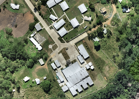
SITE INSPECTIONS AND DOCUMENTATION
Ensure your site is inspected and documented with precision and efficiency by partnering with our business! We leverage advanced drone technology to deliver comprehensive and reliable results. Using high-resolution aerial images and videos, we provide an accurate overview of your site from multiple perspectives. Our terrestrial SLAM LiDAR technology allows us to map even the most complex environments in real-time, ensuring no detail is overlooked—even in areas where GPS signals are limited. Additionally, our photogrammetry expertise transforms captured images into detailed 2D orthomosaics and 3D models for thorough documentation and analysis. With our cutting-edge approach, site inspections and documentation become faster, safer, and more effective, supporting your construction, maintenance, and safety needs. Let us help you elevate your projects with precision and innovation!
AERIAL SITE INSPECTION
ABOUT
Greymesh Solutions stands at the forefront of the aerial and terrestrial surveying industry, offering cutting-edge solutions tailored to deliver precise, dependable, and high-quality geospatial data. Our exceptional team of experts is passionately committed to harnessing the advanced capabilities of photogrammetry and LiDAR technologies, ensuring that we address the varied and complex demands of our esteemed clients. We take immense pride in empowering real estate developers, land surveyors, construction firms, utility companies, and numerous other industries with comprehensive, state-of-the-art surveying and meticulous inspection services. Through our unwavering dedication to innovation and excellence, we strive to exceed expectations and drive impactful results.

SLAM LiDAR

AERIAL LiDAR
ORTHOMOSAIC

DIGITAL TERRAIN MODEL (DTM)
CONTACT
Inquiries
For any inquiries regarding our aerial surveying and geo-spatial solutions, please feel free to contact us at
+679 9988108 or email us at surveying@greymeshsolutions.com
Request A Quote [Click link below]
Head Office
Reach out to us at our head office located at Unit 2, Legalega Industrial Subdivision, Nadi. You can also drop us an email at surveying@greymeshsolutions.com or give us a call at +679 9988108.
Employment
Join our team of dedicated professionals! If you have a passion for aerial photography, surveying, and geo-spatial technologies, send your cover letter and resume to careers@greymeshsolutions.com.